Land for sale
Yelvertoft, Northampton, Northamptonshire, NN6 6LF
Guide Price
£275,000
SOLD
UNDER OFFER
Marketed by
Howkins & Harrison, Rugby7-11 Albert Street,
Rugby,
Warwickshire,
CV21 2RX
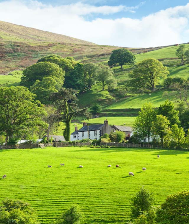
- An attractive block of pasture land located on the edge of Yelvertoft, with road frontage and long term development potential.
- 19.22 acres (7.79 ha)
- Crick 3 miles
- Rugby 7 miles
- Daventry 11 miles
- Northampton 15 miles
An attractive block of pasture land located on the edge of Yelvertoft, with road frontage and long term development potential.Extending to approximately 19.22 acres (7.79 ha).
Situation
The land is situated to the south east of Yelvertoft and adjoins the village settlement boundary. The Grand Union canal flows adjacent to the eastern boundary of the block. Being situated north east of the M1 at Crick (J18) and south of the M6 at Catthorpe, the land benefits from excellent transport links. The town of Rugby is approximately 7 miles to the east and Northampton is approximately 15 miles to the south east.
Description
Approximately 19.22 acres of land adjoining the settlement boundary (west) presented as four undulating ridge and furrow pasture enclosures, bordered by mature hedge and tree boundaries with road frontage onto Yelvertoft High Street.
The land extends to approximately 19.22 acres with road frontage onto Yelvertoft High Street from which the property can be accessed directly via a gated entrance. The land can also be accessed from Crick Bridle Road, via a gated entrance located next to the timber frame shelter. Access to the remaining enclosures is facilitated by internal gateways within the block.
The land is presented as four pasture enclosures bordered predominantly by mature hedgerow and trees and stock fencing and two strand barbed wire, there is a small pond located in field 2207.
There is a small timber framed, tin clad building with an earth floor located on the western boundary of the block, next to the entrance off Crick Bridle Road. A small concrete pad lies to the front of the building.
According to Natural England the land is classified as Grade 3 on the Agricultural Land Classification Maps, being a slowly permeable base-rich loamy and clay soil.
The land would be suited to agricultural or equestrian use and a new agricultural building or stable facility should be possible by obtaining the necessary planning permissions from West Northamptonshire Council.
Yelvertoft
As of the most recent census (2021), Yelvertoft has a population of 804. Amenities in the village include a delicatessen, pub, pre-school and Yelvertoft Primary School, which has a current capacity of 120 pupils. There is a medical centre located in the nearby village of Crick (2 miles south) along with a range of other shops and services.
Settlement
Recent development within the vicinity includes the construction of a solar farm of Crick Road, to the southwest of the village, with a generating capacity of up to 49.9MW (Ref. WND/2022/0521). Planning permission has also been approved for the construction of 9 dwellings at the western end of the village, off Hillmorton Lane (Ref. WND/2021/0946). Similarly, an application for the construction of 10 dwellings has recently been submitted for a site in the neighbouring village of Crick (WND/2022/0725).
Schedule of Acreages
Field no. AcresHectares
SP6075 1612 2.19 0.89
SP6075 22073.52 1.43
SP6074 16976.47 2.62
SP6074 28937.04 2.85
Total 19.22 7.79
Tenure & Possession
The property is offered for sale freehold with vacant possession.
Basic Payment Scheme
The land is registered to receive entitlements and these will be made available to the purchaser upon completion.
Restrictive Covenants
Not at any time thereafter to build erect or place or allow to be built erected or placed upon the Property or any part thereof any hut, tent, temporary dwelling, caravan, house on wheels or encampment intended for use as a dwelling.
Services
Mains water is connected via a field water trough. Mains electricity is believed to be nearby.
Rights of Way Etc.
Overhead wires cross the land in the southern most corner. It is believed that the property does not benefit and is not affected by any other rights of way, wayleaves or easements. A bridle way runs adjacent to the western boundary of the property and a tow path runs adjacent to the eastern boundary along the canal.
Sporting, Timber & Mineral Rights
All rights are believed to be held with the freehold owner and will be included within the sale of the land.
Boundaries & Fencing
Specific boundary ownership is unknown. The majority of the boundary of the block of land is fenced with a combination of stock fencing and two strand barbed wire.
Plan, Area & Description
The plan, area and description are believed to be correct in every way, but no claim will be entertained by the vendor or agents in respect of any error, omissions or misdescriptions. The plan is for identification purposes only.
Overage
The property will be sold subject to a development uplift clause which will reserve 30% of any increase in value due to any non-agricultural or equestrian development on the field for a period of 30 years. This will be triggered upon a sale or implementation of any planning.
Methods of Sale
The property will be offered for sale by private treaty as a whole and interested parties should submit their offers to the agent’s Rugby office.
Vendor Solicitor
Ian Riley
Fishers Solicitors, Ivanhoe Business Park, Unit R, Ashby-de-la-Zouch, LE65 2AB
Telephone: 01530 412167
Local Authorities
West Northamptonshire Council Tel. 0300 126 7000
Anglian Water Tel. 03457 145 145
Western Power Distribution Tel. 08000 963 080
Viewing
During daylight hours with a copy of these particulars to hand.
Conflict of Interest
Buyers are made aware that seller is a connected party to Howkins & Harrison LLP.
WhatThreeWords
Using the WhatThreeWords app the following will take you to the field gate:
Revives.ordeals.tycoons